I arrived home from work on Friday night with a plan for half of my running
weekend – a long one on Sunday morning with Stuart. But what to do on Saturday? This was the first of three weekends in a row
without a race, and I was quite keen to use them to cram in the miles.
I was very pleased then to get not one, but two FB messages (from Peter
and Lucy) asking if I was up to anything.
Peter was at a loose end because Mary had a course/workshop thing, and
Lucy is simply trying to increase her mileage as she gets back into running. Steve was roped in as well to make a good
band of four. After a little bit of to
and fro, we settled on a plan to start from Dunbar at high noon and do about 20
miles, once I’d returned from taxi-service duties for the kids. Excellent!

Keen to show the gang something different – Peter runs a lot on the
John Muir Way between NB and Tyninghame, and I know that he and Lucy have done
the Herring Road in the past – I opted to head east. The idea was to do a largely out and back run,
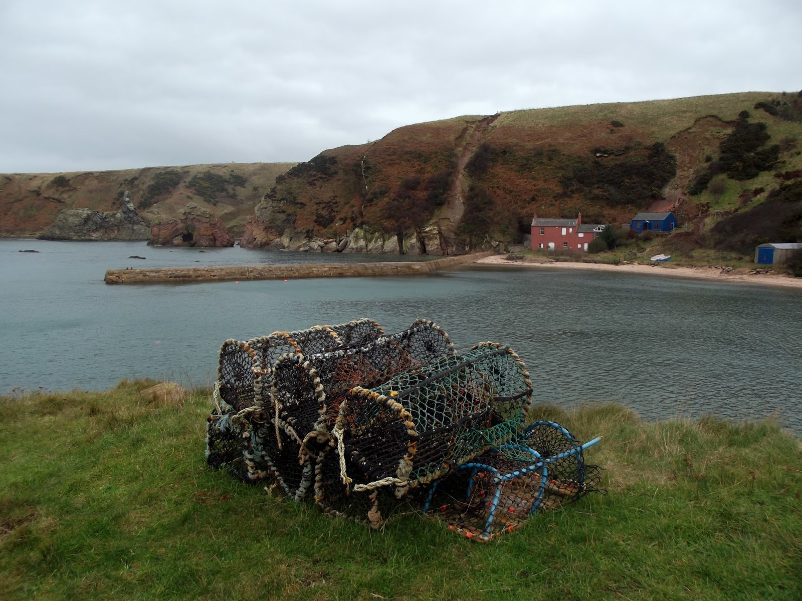
coastal for the first half, and then slightly inland on the return. Cove is an attractive little harbour about 9
or 10 miles away, so it seemed like a natural target and turning point.
We set out along the shore, skirting the edge of the golf course. The sun was out, although the wind was in our
faces. Ah well, at least it would be
with us on the way back. We all thought.
A bit of a confession. I had
never run the coastal route much beyond Whitesands/Barns Ness lighthouse. The furthest I had gone was as part of the
Dunbar leg of the Borders Cross Country series.
Instead, if I’m going out towards Cockburnspath then I’ll tend to take
the tarmacked cycle path beside the A1.
But noisy, fume-y, and earth-shuddering wasn’t really the vibe I was
going for. And a good study of Google
maps (set on satellite view) on Friday night convinced me that there were
pretty well-made paths all the way out.
I was still rather concerned about the possibility of going wrong.
At times the paths disappeared for a while, or were submerged under
water, so we ended up running on sand, stones or seaweed. Slower than the road route but, to my mind,
more rewarding in terms of things to see – check out Peter’s blog if you’d like
to look at some snaps of seals in various states of “animation”. In fact, check out his blog anyway, because
his pictures are better than mine.
Although I must have got lucky with a couple as they are nearly
identical to ones that he took.


Admittedly the Torness Nuclear Power Station is pretty brutal at close
quarters but, having lived out here for nearly 14 years, it is becoming a reassuringly
familiar sight on the horizon. In the
way that Cockenzie did before its demise.
Strange what you can come to regard with affection. Maybe that explains Jo’s largely benign
tolerance of me?!
There were a couple of lovely new spots that I (never mind Lucy, Peter
and Steve) was seeing for the first time, despite their proximity (in some
cases literally less than a couple of 100 metres away) to my more regular
haunts. Which I suppose should probably
be a lesson learned.


Cove proved something of a hit, which I was pleased about – we spent a
bit of time wandering around, having a bite to eat, and taking pictures.


After that we headed back west, with another short-ish stop at Dunglass Collegiate Church. Which, again, the gang seemed to like.


The switch back to tarmac also seemed to be helping a little, despite
the fact that the wind (typically for Dunbar) seemed to have turned so that it
remained in our faces.
The third item of interest I thought I might try to factor into the run
is the alpaca that lives in the garden of a house on the south side of the A1. Lucy had done 20 miles on Friday as well, so
was in danger of flagging, but the offer of some animal interaction (there are
also some pigs around) was well-received.
And I didn’t think this detour would add significantly to the overall
mileage.
Or at least it might not have, had I not taken the (wrong) first left
turn-off, instead of the one 400 metres later.
We ended up slogging up a hill into the wind (shock!) back towards
Oldhamstocks. Worryingly, it was not a
road that I particularly recognised either.
Rather perceptively, Lucy remarked that the direction of the road seemed
“counter-intuitive”! I had to come clean
and admit that I had stuffed up.
I was at the point of turning us around and retracing the mile or so
back to the A1 when we crested a brow and I suddenly recognised a junction that
Stuart and I often approach from the other direction. Phew – I knew where I was again, and so had a
definite route to the alpaca. Peter said
that I’d have been kicking myself if I’d looked at the Garmin feed later that
evening and realised that we’d turned around only 50 yards before the junction
had revealed itself.
Typically, the alpaca was out at the shops or getting its hair done or
some such. There was much disbelief as
to its existence, questions as to whether I had been out running drunk again,
whether I knew the difference between a pony and an alpaca, etc, etc. Lucy said that the tour was “rubbish” and she
wanted her money back. I think she was
joking at that point!
Things started to go rather quiet after Innerwick as we all tired and
the weather turned colder. Lucy asked a
couple of times how much further I thought we had to go. I reckoned perhaps 6 (when we’d already done
16). That was met with little obvious
enthusiasm, which was understandable.
When I said thank you for the lack of outright mutiny, Lucy said the
problem was that she didn’t know where she was to mutiny!
After running down to the ford below the Brunt, we elected to walk back
up the hill on the other side and eat some more on the way. I was starting to feel a little flaky, so
thought I’d call to see if Jo could come out and collect us, which thankfully
she did. I wish I’d thought of that
sooner.
Back to the house for restorative hot beverages, our new puppy/insect
hybrid Roo helped to cheer everyone up before Steve ferried everyone back to
Edinburgh.
Overall I think it was a successful outing, but I should perhaps take a
leaf out of Richard H’s book and do a complete recce of an experimental route
the day before purporting to guide others around it.

--------------------------------------------------------------------------
9am on Sunday morning came around all too soon, and I made my way up to
Woodhall to meet Stuart. Given the
previous day’s coastal route, I elected for the “other option” of the run up
and over the windfarms towards Whiteadder.
A decision which I was regretting within 2 miles. 2 miles that were pretty much continually up,
on heavy legs, and directly into the teeth of the wind. It crossed my mind to ask Stuart if we could
reduce our planned 18 miles slightly. To
something more like 4.
But that is why it is good to run with someone else at times like these
– you each borrow the other’s will-power and keep going. The first 6 miles were undeniably tough –
aching thighs, little chat, and no shortage of tears and snotters. At least on my part.
But once we got to the top of Crystal Rigg, the rocky path down towards
Whiteadder brought some measure of relief, and before long we were back on
tarmac with the wind at our backs. Much
better.
 |
| 1965 - no reservoir |
 |
| 2016 - no Kingside School |
And the wind actually seemed to be helping to push us back up the hill
at Harehead. We then took the Monynut
Wood route back down to Elmscleugh. The
coast down the long hill could only have been better if I was freewheeling on a
bike.
Getting back to Woodhall saw us rack up around 19.4 miles and, for me,
a smidge over 41 for the weekend. Happy
with that. Here’s to more of the same
before my next race (the Borders XC) on 14 February.
